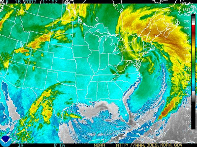
Now that is a Nor'easter

If you ever wanted to see a classic comma shaped low typical of the Nor'easter - here is a textbook example. I'll call this one the "Tax Day Storm". Note how massive these storms can become - with the low centered right over NYC (see the center of the spiral) and a dense shield of precipitation rotating counter-clockwise off of the North Atlantic and into the Canadian Maritimes and the New England states and a front that extends down to the Bahamas.
The pressure currently is 28.66 inches of Hg in NYC which is about as low as these storms will produce and is on the order of a small hurricane.
Additionally, this storm is occuring about a month later than it should. Most Nor'easters in March can be very powerful (the St Patrick's Day storm this year) but the synoptic pattern changes of Spring tend to suppress the deep troughs in the jet stream needed to form these storms. However, this year is unlike most. A strong El Nino in December and January turned into a classic winter pattern dominated by polar highs and coastal lows. We've had a bipolar winter!
Note that weak El Nino years tend to mean lots of summer hurricanes. They should start to appear in the Gulf of Mexico in two months - usually some weak hurricanes will first form in the Gulf and ride up over the Florida Peninsula and along the east coast in mid- to late- June.
2 Comments:
Impressive for sure...Combined with a cold, my sinuses are literally killing me as a result.
I am very "pressure sensitive"...not to mention, just "sensitive" :)
I too am pressure sensitive. Headache appears. Headache disappears. And so on.
Are you and Mike gonna play 'dueling nor'easters' on your respective blogs?
Post a Comment
<< Home